Pedal to the Kettle
Visit york.ca/cycling for a full list of trails and GPS map downloads!
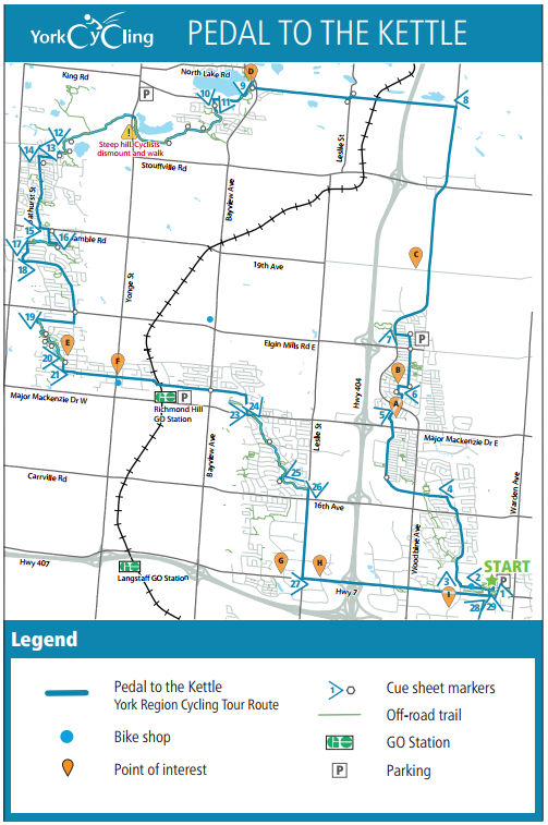
Beginning at the Markham Town Square, this route features the Oak Ridges Corridor Park Trail, a more than 1,000 acre park and home to wetlands and forests. You'll pass Mill Pond Park, the original power source for the first sawmill in the area. When arriving in the woodbine and Major Mackenzie area, catch a glimpse of the massive Slovak Cathedral of Transfiguration. You will ride through the lakeside community of Wilcox lake and can look forward to finishing at one of the many restaurants along the bicycle-friendly stretch of highway 7.
City of Markham, Town
of Richmond Hill
Length: 48km
Ride Rating:
Recreational cyclist – mostly bike lanes and
paved shoulders on busier roads, and trail
Experienced road cyclist option – bypass
the Oak Ridges Corridor Conservation
Reserve trail by using Bathurst to King Rd
and Sunset Beach Blvd
Family/leisure option – ride the Oak
Ridges Corridor Conservation Reserve Trail
from Bathurst Glen Golf Course to Oak
Ridges Community Centre
Surface: Road, unpaved trail (limestone
screenings)
Possible Starting Points:
We suggest starting at these free day
parking locations:
» Markham Civic Centre – optimal for
suggested itinerary; restaurants,
washrooms and water
» Richmond Hill Town Office – restaurants,
washrooms and water
» Richmond Hill GO Station
» Hotel options on Hwy 7
This trail map is available in our store for free. Pick one up before you ride!
Ride Directions
START - Markham Civic Centre
Terrain: Road
1. Turn RIGHT onto Town Centre Blvd
2. Turn LEFT onto Apple
Creek Blvd 0.6 km | 0.9 km
3. Turn RIGHT onto Rodick Rd 1.5 km | 1.7 km
4. Turn LEFT onto Calvert Rd 3.2 km | 2.9 km
a. Continue onto Markland St
5. Turn RIGHT onto Russell Dawson Rd 6.1 km | 0.8 km
6. Turn LEFT onto Donald Buttress Blvd W 6.9 km | 2.0 km
a. Turn RIGHT at Refl ection Rd
b. Turn RIGHT onto Anthony Roman Ave
c. Continue LEFT onto Prince Regent St
d. CONTINUE onto Duke of York St
e. Turn LEFT onto Prince of Wales Dr
7. Turn RIGHT onto Woodbine Ave 8.9 km | 6.4 km
8. Turn LEFT onto Bethesda Sdrd 15.3 km | 4.4 km
a. Turn LEFT onto Leslie St
b. Turn RIGHT back onto Bethesda Sdrd
c. CONTINUE onto the trail past Bayview Ave
Terrain:Trail
9.
CONTINUE onto Sunset Beach Rd 19.7 km | 0.6 km
Terrain: Road
10. Turn LEFT onto Park Cres 20.3 km | 0.3 km
a. LEFT onto Sandbanks Dr
11. Turn RIGHT onto Oak Ridges Trail through the 20.6 km | 5.1 km playground
Terrain: Trail
a. Keep LEFT at the fork
b. Keep RIGHT at the fork
c. Keep LEFT at the fork
d. Turn RIGHT to stay on Oak Ridges Trail
e. Turn RIGHT to stay on Oak Ridges Trail
f. Keep LEFT at the fork by Philips Lake
g. Turn RIGHT at the fork towards Milos Rd
12. Turn LEFT onto Philips View Cres 25.7 km | 0.2 km
a. Turn LEFT onto Milos Rd
13. Terrain: Road
14. Turn RIGHT onto
Township Ave 25.9 km | 0.4 km
.
15. Turn LEFT onto Lourakis St 26.3 km | 1.8 km
a. CONTINUE onto Selwyn Rd
16. Turn LEFT onto Gamble Rd 28.1 km | 0.7 km
a. Turn RIGHT onto Colesbrook Rd
17. Turn RIGHT onto Eagle
Peak Dr 28.8 km | 0.8 km
a. Turn RIGHT onto Trans Richmond Trail
Terrain: Trail
18. Turn LEFT onto Casa
Grande St 29.6 km | 0.5 km
Terrain: Road
19. Turn LEFT onto
Shaftsbury Ave 30.1 km | 3.2 km
a. CONTINUE onto Regent St
20. Turn LEFT onto the trail 33.3 km | 0.9 km
Terrain: Trail
a. Turn LEFT at the fork
b. Turn LEFT at the fork
c. Turn RIGHT at the fork
d. Turn LEFT at the fork
21. Turn LEFT onto Mill St 34.2 km | 0.4 km
Terrain: Road
a. Turn RIGHT onto Trench St
22. Turn LEFT onto Centre St 34.6 km | 3.6 km
a. CONTINUE onto Farmstead Rd
23. Turn RIGHT onto Frank
Endean Rd 38.2 km | 0.5 km
24. Turn LEFT onto Major
Mackenzie Dr E 38.7km | 0.1 km
25. Turn RIGHT onto the trail 38.8 km | 1.8 km
Terrain: Trail
a. Turn LEFT at the fork
26. Turn RIGHT onto Boake Trail 40.6 km | 0.6 km
a. Turn LEFT onto the trail
27. Turn RIGHT onto Leslie St 41.2 km | 2.3 km
Terrain: Road
28. Turn LEFT onto Hwy 7 43.5 km | 3.7 km
29. Turn LEFT onto Town
Centre Blvd 47.2 km | 0.1 km
30. Turn RIGHT onto Cox Blvd 47.3 km | 0.2 km
Maps and directions courtesy of