York Century
Visit york.ca/cycling for a full list of trails and GPS map downloads!
The 'century' is a legendary ride among cyclists originating in the late 1800's. The more modern "metric century" in York Region offers a memorable route easily accessed from anywhere in the GTA. Starting in Newmarket, this smoothly paved route takes you to Lake Simcoe and provides plenty of stops to re-charge. Consider lunch or an overnight at the luxurious Bria's Resort and Spa. You will surely enjoy the historic villages along the way. Plan to linger along the Simcoe shoreline and enjoy the spectacular views from Lake Drive.
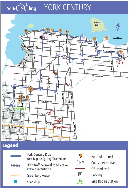
Towns of Newmarket, Sharon, Queensville, Keswick & Sutton
Length: 100km
Ride Rating:
Experienced road cyclist – paved shoulders and mixed traffic on quieter roads
Recreational cyclists option – ride along Lake Drive and Hedge Road from Keswick to Sibbald Point Provincial Park
Surface: Road
Possible Starting Points:
- Davis Drive and Highway 404 Carpool Lot (Newmarket) – overnight parking
- Woodbine and Highway 404 Carpool Lot (East Gwillimbury) – overnight parking
- York Regional Forest Brown Hill Tract (East Gwillimbury) – overnight parking
- The ROC (Georgina) – overnight parking
- Accommodations at B&Bs, Briar’s Resort or camping at Sibbald Point Provincial Park
Morning Glory Rd/
Concession Rd 6 46.4 km | 5.0 km
11. Turn RIGHT onto
Stoney Batter Rd 51.3 km | 6.5 km
a. Turn LEFT onto Hwy 48
b. Turn RIGHT onto Hadden Rd
c. Continue onto Black River Rd
12. Turn RIGHT onto
York Regional Rd 18/
Park Rd 57.8 km | 2.5 km
13. Turn LEFT onto
Hedge Rd 59.3 km | 3.2 km
14. Turn LEFT onto
Lake Dr East 62.5 km | 4.5 km
15. Turn LEFT onto
Civic Centre Rd 69.2 km | 18.3 km
a. Turn LEFT onto Baseline Rd
b. Turn RIGHT onto Warden Ave
16. Turn RIGHT onto
Queensville Sd Rd 87.5 km | 6.2 km
17. Turn LEFT onto
2nd Concession Rd 93.7 km | 6.2 km
18. Turn LEFT onto
Green Lane 99.9 km | 0.1 km
Maps and directions courtesy of

This trail map is available in our store for free. Pick one up before you ride!
Ride Directions
START - East Gwillimbury GO Station
Terrain: Road
1. Turn LEFT onto
Green Lane East 0.0 km | 0.0 km
2. Turn RIGHT onto
2nd Concession Rd 0.2 km | 6.2 km
3. Turn RIGHT onto
Queensville Sd Rd 6.4 km | 10.3 km
a. Turn RIGHT onto Warden Ave
b. Turn LEFT back onto Queensville
Sd Rd
4. Turn LEFT onto
McCowan Rd 16.7 km | 11.3 km
5. Turn RIGHT onto
Baldwin Rd 28.0 km | 6.2 km
a. Turn LEFT onto Hwy 48
b. Turn RIGHT onto Smith Blvd
6. Turn LEFT onto
Park Rd 34.2 km | 1.4 km
7. Turn RIGHT onto
Old Homestead Rd 35.6 km | 8.8 km
8. Turn LEFT onto
Station Rd 44.4 km | 1.0 km
9. Turn LEFT onto
Pefferlaw Rd 45.4 km | 1.0 km